Shawnee County braces for flooding as heavy rain targets I-70 corridor
Emergency officials warn motorists to avoid flooded roadways as up to 3 inches of rain expected through Friday

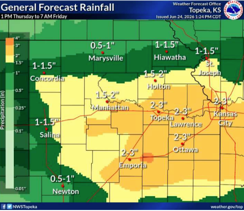
TOPEKA, Kan. — Residents and motorists in Shawnee County along and south of Interstate 70 face a renewed flood threat as incoming storms are forecast to drop 1 to 3 inches of rain across the region from Thursday afternoon into Friday morning. With the ground already saturated from earlier June downpours, local emergency management officials have activated a flood watch, warning that isolated areas could see higher totals. While waterways and reservoir releases are not currently a major concern, the county's Emergency Operations Center is actively monitoring water levels as the heavy rain moves in.
Authorities are urging drivers to remain vigilant, echoing the National Weather Service's "turn around, don't drown" advisory. State officials routinely urge Kansans to avoid crossing flooded roadways during severe weather. Forecasters note some uncertainty about exactly how widespread the heaviest precipitation will be, but say there is high confidence that communities along the I-70 corridor will experience intense downpours throughout Thursday night.
Found a mistake? Have a news tip or feedback to share? Contact our newsroom using the button below:
